
Description
ABOUT
Simple Map Locator has been developed entirely in php, html and jquery.
It’s simple and intuitive: just use the backend to create as many maps and markers you want!
Based on OpenStreetMap, no need api key and annoying quota limits! Ready to use!!
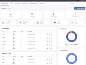
BACKEND DEMO
– Administrator Login (user: demo / passw: test1234)
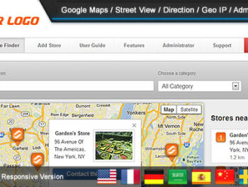
MAP DEMO
View demo map here
NEED SUPPORT?
Open a ticket here
FEATURES VIEWER
– map with different styles (OSM, Maptiler, Here, Google, Custom)
– markers with clustering and icons
– markers list
– marker’s sheet detail with images
– marker’s connection with lines
– story
– globe view
– reviews and ratings
– directions and street view links
– social share
– geolocation
– geoJSON, KML, GPX
– geo images
– custom logo
. password protection
– google analytics integration
– responsive
FEATURES BACKEND
– simple installation
– built-in upgrade
– dashboard
– create / edit customers, editors and administrators (multi users)
– create / edit maps (logo, style, name)
– duplicate maps
– add / edit markers (details, icon, position, images)
– draw geometries
– preview
– publish (link or embed code generator)
– responsive
– multi-language
REQUIREMENTS
– PHP and MYSQL
INSTALLATION
easy, and guided with a wizard, read the readme.txt for more info
CHANGELOG
4.6
- added Google as map style
- added the ability to place georeferenced images on the map
- added the ability to import geo-data (geojson,json,kml,gpx) into map
- added the ability to set the language for Here and Google map styles
- added the ability to search inside the backend map's list
- added the ability to set miles as unit map
- added the ability to open a link externally or in a modal when a marker is clicked
- added the ability to set the visibility of a marker in the map and search
- added the ability to set a map as a template for creating new ones
- added the ability to fit the map or not on the filtered markers in the categories
- now when add/edit markers into backend also geometries and geojson are displayed on the map
- now the geometry section has the correct map style configured with the road/satellite toggle
- now the marker hover style is applied even when its tab is open
- redesigned error pages and added the ability to replace them
- fixed geometries not drawn if there is no markers
- fixed default map view not being applied
- fixed marker's icons without background color
- fixed satellite style not changing correctly on backend
4.5
- added dark mode into backend
- added the ability to insert intros to maps
- reorganized the section to change the map style
- added more maptiler / here styles to maps
- added the ability to enable / disable share providers inside the backend and map settings
- added more sharing providers into maps
- added share map button
- sharing a specific marker now retrieves the marker's meta tags instead of those of the map
- added the ability to set the target (self / new window) for opening tours within showcases
- added the ability to set terms and conditions, privacy policy and cookie policy
- added the ability to enable Cookie Consent into backend / showcase / maps
- added overall statistics
- added English (British) language
- reorganized backend menu
- fixed an issue with deleting the showcase not working
- fixed an issue that prevented the default marker icon from saving
- fixed an issue exporting the markers
- fixed an issue exiting the geolocation on mobile freeze the touch on the map
4.4
- added Openroute Service integration for built-in directions
- added the ability to set a radius for search markers
- added a parameter to the url to automatically open the "add marker"
- added the ability to schedule markers
- added the ability to set the default extra fields icon
- added the ability to set which field to make visible when adding markers from the map
- added Finnish language
- updated Fontawesome icons
4.3
- added the ability to create showcases
- added map loading screen
- added the ability to select the map provider to show the directions of a marker chosen from Google, Bing, Baidu and Yandex
- added the ability to select the map provider to show the street view of a marker chosen from Google, Bing and Yandex
- added satellite view also on adding marker from backend
- added a map type for large number of markers
- added the ability to duplicate a marker into a different map
- optimized performance and loading
- fixed direction link not working on some systems
4.2
- added the ability to place a marker when hovering over search results
- added the ability to open extra content instead of marker window detail
- added the ability to insert/import marker without coordinates
- added the ability to batch geocode all the markers that not have coordinates
- added alternative font providers
- more responsive on mobile
- fixed generation of marker's QR codes
4.1.1
- fixed an issue that prevent add new markers
4.1
- added the ability to set a different logo for mobile
- added the ability to set the size of the logo
- added the ability to set an url to the logo
- added hover style colors for markers
- added the ability to upload multiple images into markers
- added the ability to set and view marker detail windows as reduced or opened on mobile
- added the ability to put custom css / js / head elements into maps and backend
- added "remember me" into login page
- added show/hide passwords on login page
- added an alternative login page style
- featured marker clicked now is highlighted
- when adding/editing a marker now the map has the same style as configured in the settings
- fixed an issue on some system that prevent open the direct marker link
4.0
- added the ability for markers to open the details window or not
- added the ability for markers to view the popup or not
- added the ability to set the marker popup image height
- added the ability to set the marker popup background and color
- added more bulk actions for markers
- upgraded the map rendering engine
- organized the markers edit page into tabs
- improved the import of the marker file exported from another map
- fixed categories not showing on adding a new marker from map
- fixed hours and description font sizes
3.9.1
- added the ability to auto-approve markers added from map
- added the ability to select multiple categories into markers added from map
- fixed scroll issue on sheet detail on mobile
- improved security
3.9
- added the ability to draws geometries on map
- added shortcuts to simplify adding extra field values
- added bulk delete markers
- extended search for all fields
- updated map access graph into statistics
- fixed geojson colors not being applied
- fixed an issue filtering by category sometimes gave empty results
3.8
- added Globe view
- added Categories Filter Type (AND / OR)
- added some graphical changes to the backend
- added the ability to share and open the link of a map into the Publish section
- added the ability to set meta tags of the map
- fixed an issue with the default language
3.7
- added weather
- added Indonesian language
- added the ability to massively assign an icon style to markers from the map or category
- now you can drag the marker to change its position on the add/edit marker sections
- when you add a new marker the map is now centered based on the previously added markers
- update the core map library
- fixed an issue with search box when geolocation is on
3.6
- added support to geoJSON
- added pop-up details when moving between markers in the story
- added an option to publish the map as the first page of your domain
- added the possibility to set the order of the markers by priority, name or city
- when adding a new marker from the map you are now asked whether to use your position or not
- fixed search issue when geolocation is on
3.5
- added featured markers
- added the ability to highlight the position of the markers when you hover the mouse over the search results
- fixed a flickering issue when there are many icons
- fixed an issue preventing review texts from wrapping
3.4
- now adding a marker from the map takes the default style set in the settings
- added the possibility to select the category in the new markers mode on the map
- added the possibility to delete images in the new markers mode on the map
- fixed an issue with editor permissions
- fixed add marker not working when geolocation is enabled
- fixed an issue that prevented the display of the marker list when the city search was active
3.3
- added Korean, Thai languages
- added the ability to search location / city into maps
- added attributions for maps
- added the possibility to set for each marker the zoom level in which it must appear
- added default style parameters for markers in map settings
- added the ability to duplicate markers
- increase quality of image icons
- fixed an issue on geolocation
- fixed an issue for some systems not displaying the markers list on the backend
3.2
- redesigned the search box which is now always visible on the map
- added the story feature that allows you to scroll through the markers in a narrative way
- added the ability to disable/enable search, list and categories filter
- added the ability to change font for maps
- added the ability to change the default view for maps (street or satellite)
- added am option to set the quality of the map
- added an option to activate geolocation on map load
- added an option to set the default zoom for geolocation
- increased number of extra fields to 20
- now import excel can also update markers if the id is provided
- improved the click of markers on mobile devices
- improved the performance of the list and the search with many markers
- fixed an issue on saving settings
- fixed an issue that prevented some markers from displaying in the backend
3.1
- restyled the viewer
- added controls arrows to loop through the markers
- added the ability to sort markers
- added the ability to add markers directly from maps
- added the validation of the markers inserted from the map
- added the ability to individually disable directions, street view and reviews buttons for markers
- added a customizable button to each markers that open a modal with an html content such iframe text or others
- added toggle button to show or hide marker connections
- on the map with a single marker some controls are hidden
- hide connection between markers not visible
3.0
- added fullscreen mode
- added parameter to set the density distance that allows you to group markers together
- added the possibility to center the map on a selected marker
- added edit next / previous marker buttons into edit marker's page
- redesigned the selection of marker icons in the backend
- added editor role with permissions
- added captcha verification for reviews
- added marker zoom's option into maps to control the zoom level when the marker is clicked
- removed empty image space from popup and sheets
- the icons in the marker detail tab have been moved and grouped under the name
- added street view link
- added popup to marker connections with customizable title and description
- added edit button shortcut near map selector
2.9.2
- fixed an issue with category filters
2.9.1
- added customizable items on backend's footer
- added Romanian language
- move delete into the marker's list
- fixed bug on adding marker
2.9
- added the ability to update the application automatically (only for administrators)
- added marker's connections to draw a line between them
- added custom map style
- added zoom controls to map
- added the ability to set background, color and size of each individual marker
- added icon preview in marker's list
- added the ability to set marker's custom fields values with html content
- added the ability to duplicate maps
- added Swedish language
- modified the import template excel with all the markers parameters
- fixed bug hide rating when review is disabled
- fixed bug on import markers
- fixed upload of icon with size too small
- fixed encoding on export csv
2.8
- added multi-language backend / viewer
- added language switcher for backend
- added the ability to change language for maps
- added the ability to change font for backend and viewer
- added the ability to change theme color for backend
- added custom logo for backend
- added custom image for login page
- added the ability to edit profile for change username, language and password
- added custom css editors for backend and viewer maps
2.7
- added whatsapp field to markers
- added preview box when hover the markers
- added pinned flag to markers to shows on top of the list
- added sub categories
- added the ability to assign a marker to multiple categories
- added categories in exported markers file
- added statistics
- added gif compatibility for icon markers
2.6
- added a button to toggle categories filter
- fixed map not showing
2.5
- fixed a bug that deletes the icon library when saving marker
- added the ability to administrators to change the user owner of the map
- added markers size
- added review system with ratings
2.4
- added cursor pointer to markers
- click the grouped markers to expand them
- added url variables &coord=xxxxx,yyyyy&zoom=z (xxxxx = lat, yyyyy = lon, z = zoom)
2.3
- improved search with also description and custom fields
- added direct links to markers and categories
- added satellite view switcher
2.2.1
- fixed import of markers
2.2
- fixed bug on generating thumbs
- fixed bug on duplicating images when saving marker multiple times
- added density color toggle to maps to displays different colors based on the density of marker grouping
- added checkbox and counts on map's categories
- reset the sort order of the marker list when geolocation is off
- added a flag to the categories to be selected as default
- the map is centered on the position of the first geolocation
- added password to protect the map
2.1
- added custom icon library
- added extra fields to markers
- website url in sheet is now clickable
- the address fields are now not mandatory
- adjust zoom on click categories to fit the markers
2.0.1
- fixed bug on sorting list
- fixed bug on search
2.0
- added categories to markers
- added filter by category on maps
1.9.1
- fixed a bug on geolocation not working on iframe
- ignoring not valid coordinates on viewer
1.9
- added an option to maps to auto show marker's list
- added default zoom option to maps
- added a search box in the marker's list
1.8
- added possibility to change single marker color
1.7
- added a button to convert marker's address to its coordinates
- fixed a bug on import excel markers
1.6
- added an active parameter to markers to enable or disable it
1.5.1
- added possibility to get coordinates with gps to set marker position
- added possibility to delete users
- bugfix on initial map loading
1.5
- added to dashboard a chart with num markers grouped by maps
- added possibility to export all markers of a map
- added possibility to activate / deactivate maps
- added friendly url to publish link with a custom url
- added google analytics integration
1.4.1
- minor bugfix on import markers
1.4
- import massive markers with excel
- added users menu backend (only for administrator): manage customers and administrators who can use the application
1.3
- added possibility to input lat / lon manually
1.2
- added marker icons (fontawesome)
- added directions button
- fixed gallery images
1.1
- maptiler integration
1.0
- initial release


There are no reviews yet.